Annual Long Walk @ Sunset Peak, 2011

交通 Transportation details:(東涌巴士總站→3M [梅窩] / 11號 [大澳] 巴士→伯公坳站下車→鳳凰徑→經大東山及二東山→下山至 南山終點)
(Tung Chung Bus Terminus [Near Tung Chung MTR station] →NLB bus no.3M [To Mui Wo] / no. 11 [To Tai O] →Get off @ Pak Kung Au→Lantau Trail entrance→Walk via Sunset Peak and Mount Yi Tung Shan→Downhill to Nam Shan [South Mountain] end point)
巴士時間表 Bus Schedule:http://www.newlantaobus.com/road_11.htm (No. 11)http://www.newlantaobus.com/road_3M.htm (No. 3M)
小輪時間表 Ferry Schedule:http://www.nwff.com.hk/cht/fare_table/central-mui_wo/ (中文)http://www.nwff.com.hk/eng/fare_table/central-mui_wo/ (ENG)
官方地圖 Official Map for the trail:http://www.hkwalkers.net/eng/pdf/longtrail/ltrail/lmap02.pdf (中文 & ENG)
Album:
http://www.fotop.net/medalene/17dec11SunsetPeak?page=1
http://www.fotop.net/medalene/17dec11SunsetPeak?page=2
http://www.fotop.net/medalene/17dec11SunsetPeak?page=3
http://www.fotop.net/medalene/17dec11SunsetPeak?page=4
http://www.fotop.net/medalene/17dec11SunsetPeak?page=5
http://www.fotop.net/medalene/17dec11SunsetPeak?page=6
http://www.fotop.net/medalene/17dec11SunsetPeak?page=7
http://medalene.blogspot.com/2011/12/sunset-peak-2011.html


終於又是一年一度的大東山之行~~ 從東涌的伯公坳出發, 經大東山看山上的石屋, 然後再下山至南山!!
全程6.5公里, 在伯公坳上山的路會很斜, 不過路程較短, 記得先拉筋, 以防腳部抽筋!
上走一段極斜石級後, 回頭可見對面的鳳凰山!!
J
Our annual walk to Sunset Peak in 2011~~ Starts from Pak Kung Au of Tung Chung, then walk uphill to Sunset Peak,
to see those beautiful camp houses near the hilltop!! And afterwards, walk downhill to Nam Shan (near Mui Wo).
The whole track is around 6.5km, and the path is very steep near Pak Kung Au, but it is a bit shorter than the trail startiing from Mui Wo.
Remember to do some "warm-up" exercise or do some stretching first before you walk uphill.
After walking up from the steep staircases, you can see Lantau Peak clearly which is at the opposite side.

唱歌石~ 山上大風, 它好像有點小洞, 風一吹即發出陣陣"走音" 怪聲.
J
A singing stone~ very windy this morning, is it hollow inside, or because many holes on it??
When the wind hit it, the echoes just like it was singing.... a drunk man was singing.... completely off-key.... so bad...


走過數個山頭, 到了.... "奶媽峯" (Nelson 說這小山峯像女人的....., 令行山人士有溫暖的感覺... 唉!!!)
J
Walking up and up.... we had reached this little "hilltop"~ Nelson said this part (the photo at the bottom) looks like a milking woman, which can give love and warmth to the hikers!!!!


藍天白雲+山風
J
Beautiful clouds && mountain breeze

看到大東山的石屋了!! 小心, 這一段路非常斜, 又多沙石.
J
We could see the stone houses @ Sunset Peak!!! This part is quite steep and very bumpy, be careful when you walk down from here.


完成了伯公坳2.5公里的路段, 這裡高度約800多米, 仍有4公里下山路才到南山!! 先在大東山看風景, 吃飯+大休!!!
J
Had completed 2.5km's walk from Pak Kung Au, about 810m above sea level @ this part, but still with a 4km long trail for downhill!!
Take a rest first, then go around to see those beautiful camp houses and have our lunch near those houses along the hillside.


近看"蠄蟝石"及15號石屋, 之後在草原上跑.
J
Had a close-up of "Toad Stone" and House no.15, then running on the golden grassland.


在18號石屋附近.
J
Playing near House no.18.

16號石屋
J
House no.16.


花老B 遊走黃金草原, 之後向鏡頭一笑.. :D
J
Tachibana san was running on the golden grassland again.... then he suddenly turned his face to the camera, giving us a sweet smile. :D

又見小屋.
J
Another stone house.


在11號小屋外發現外星人遺跡!!?? 古老的水缸, 古怪的木桿可能是與火星通訊的設備..... :P
J
Discovered remains from Martians outside house no.11!!????
See the old water tank and a strange wooden pole, which looks like Martians' work... Hahaha!! :P
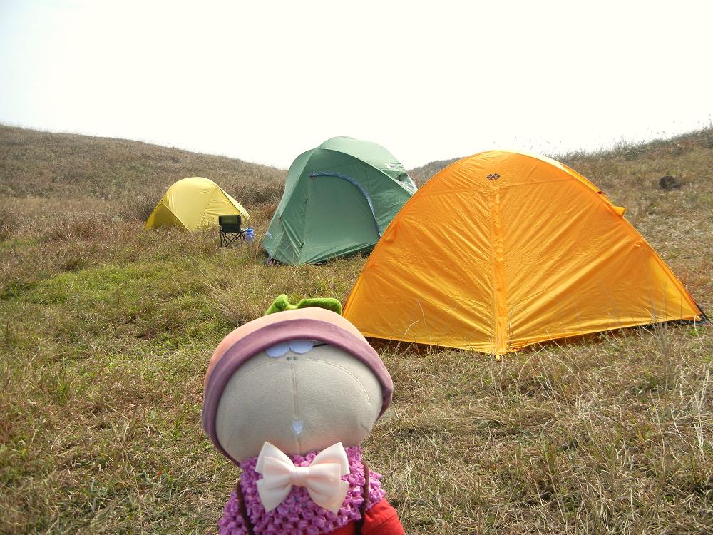
在風勢如此強勁的營地上睡覺, 真的不簡單!! 此地以風勢強勁聞名的.
J
Wooow!! What a hard work to setup tents near the hilltop!! Not easy to setup tents at this place, as this camp site is well-known for the frequent strong winds over days and nights.

上二東山的山頂了!! (她是全港第四高的山, 約747米)
J
Now moving to the top of Mount Yi Tung Shan, which is the 4th highest mountain in HK, about 747 metres above sea level.


山上的石屋上, 有租用的資料, 想來石屋住一晚可參考相關網址. 8號石屋是最美麗的一間, 大家不妨來看看.
J
There are URL and email about the rental of stone houses @ Sunset Peak and Mount Yi Tung Shan.
House no.8 is the prettiest of all, have a look when you come here.


山上風景如畫.
J
Beautiful scenes everywhere!


山上遇上流浪小狗.... 只見牠從黃龍坑郊遊徑下山了, 希望牠安全到步.
J
Met a little stray dog near Mount Yi Tung Shan.... I saw it running down from Wong Lung Hang Country Trail, maybe it came up from there also.
Hope it can reach "home" safely.


林內的樹神.... :D
J
Tree fairy inside the woods.


L011 附近有往南山的黃色指示牌, 旁邊的山路可通往全港第五高的蓮花山
J
There's a yellow direction sign (for Nam Shan) near Distance Post L011.
There's a footpath nearby, which is leading to the 5th highest mountain in HK~ Lotus Hill (Mount Lin Fa Shan)


穿林及經過貼崖之地... 大家小心.
J
Walked via woods and some places near the cliff....

很多沙石.... 很滑的一段... 話未完, 即跌到險些屁股開花.
J
Slippery and bumpy sandy path.... then... a big fall... oh... pain and pain....


林內較陰暗, 才下午3時已有黃昏感覺.
J
The woods were quite dark.... just 15:00!!


向南山方向走, 會見L006標柱.
J
Just walk to the way for Nam Shan and you will see distance post L006...


報告!! L006附近發現麥田圈!!! 還有火星人基地的遺址!!! Hahaha!!!! 只不過是直昇機坪而已!!!
J
URGENT!!! Crop circle near Distance Post L006!!!!! And remains of Martians' military site!!
Hahahaa!!! Just a helicopter pad!!!


鳳凰徑前留影.
J
Cheers!!!! Just @ the entrance of Lantau Trail @ Nam Shan BBQ site.
沒有留言:
張貼留言