西灣浪茄萬宜軟腳大長征
Super Long Hike for Sai Wan, Long Ke and High Island Reservoir (approx 17km)
(西貢親民街 29R 村巴→西灣亭→吹筒坳→西灣山→浪茄村→浪茄灣→獨孤山→萬宜路→萬宜水庫東壩→萬宜水庫西壩→萬宜路入口→大網仔路→上窰村巴士站→回西貢碼頭 / 市區)
(Village bus no.29R @ Chan Min Street [outside McDonald's Restaurant] →Sai Wan Pavilion→Chui Tung Au→Mt. Sai Wan Shan→Long Ke Village→Long Ke Beach [Camp site] →Mt. Tuk Gu Shan→Sai Kung Man Yee Road→East Dam of High Island Reservoir→West Dam of High Island Reservoir→Entrance of Sai Kung Man Yee Road→Tai Mong Tsai Road→Bus-stop @ Sheung Yiu Village→Back to Sai Kung Pier or the urban area)
Album:
http://www.fotop.net/medalene/23mar14LongKe?page=1
http://www.fotop.net/medalene/23mar14LongKe?page=2
http://www.fotop.net/medalene/23mar14LongKe?page=3
http://www.fotop.net/medalene/23mar14LongKe?page=4
http://www.fotop.net/medalene/23mar14LongKe?page=5
http://www.fotop.net/medalene/23mar14LongKe?page=6
http://www.fotop.net/medalene/23mar14LongKe?page=7
http://www.fotop.net/medalene/23mar14LongKe?page=8
http://www.fotop.net/medalene/23mar14LongKe?page=9
http://medalene.blogspot.com/2014/03/20140323-long-ke-n-high-island-reservoir.html


今天展開浪茄萬宜大長征, 很早便乘29R 村巴到西灣亭. 在西灣亭附近, 看見貼出了西灣村又被封的告示!!! 可怒也!!!! 不過後來政府介入此事, 現在應該解封了.
Today was our super long hike for Long Ke and High Island Reservoir, so we arrived Sai Wan Pavilion (by village bus no.29R @ Sai Kung) early in the morning (10:00 am).
Quite shocked to see a notice about the road blockage again in Sai Wan Village (Angry!!!!!) when we were near the entrance.
But as some government officials had some negotiations with the villagers, everything should be back to normal a few days later.


雖然今天不是去西灣村, 但往浪茄仍是先步向西灣村的方向, 再去吹筒坳.
Although we were not going for Sai Wan Village today, but we must walk to the way for Sai Wan Village first in order to go for Long Ke via Chui Tung Au.

往浪茄的早段 -- 山上遠眺大浪西灣及蚺蛇尖 (最左邊).
The first part of the trail for Long Ke -- Looking at Tai Long Sai Wan beach and Sharp Peak (The most Left one).

準備登上對面的西灣山.
Now we were moving up to Sai Wan Shan peak.


上西灣山的路, 沙石極多, 有點吃力.
Most of the mountain track for Sai Wan Shan peak is gravelly, a bit more effort is necessary.


終於到了山上的觀景台.... 山景異常吸引, 不枉此行.
Now we were @ the view compass of Sai Wan Shan peak..... beautiful scenes around us, worth to climb up for a look.


終於到了西灣山的頂部.
Now we were @ the top of Sai Wan Shan peak.


在西灣山的山頂涼亭小休 10分鐘 (包括午飯!!), 怱怱續向浪茄方向走. 山下浪茄灣的風景極美, 不過下山的路卻越來越難走. 在佈滿碎石又斜的山坡上行走, 小心慢行.
We had a 10 minutes' break (including lunch) @ the Sai Wan Shan pavilion, then we continued our long walk for Long Ke.
The trail becomes more and more challenging ---- we had quite a hard time moving downhill via a steep and gravelly slope (although it is called a "footpath")


向萬宜路前進 -- 這段路又斜又滑很難走.....
Now moving to the way for Man Yee Road --- this is the most horrible part -- gravelly, steep and loose ground.... strong knees are needed!!


浪茄灣就在眼前.... 仍要走一段路... 加油!!!
Ya, we could see Long Ke Beach from here.... just keep on moving!!!

真的累了, 大家在另一個涼亭來個 10分鐘休息.
We were tired and having another 10 minutes' break @ the 2nd pavilion. (Time for biscuits!!!!)

回望西灣山.
Looking back to Sai Wan Shan peak.

獨孤山.
Tuk Gu Shan peak (Lonesome Peak?!!?!?!)

浪茄福音戒毒村.
Long Ke Village -- a gospel drug rehabilitation centre.


下山到了浪茄村, 這裡亦是福音戒毒中心, 環境優美.
Now we were @ Long Ke Village, also a gospel drug rehabilitation centre, with beautiful nature surrounding the whole place.


浪茄灣真的很美, 可惜我們要趕路, 不能在此久留, 可惜!!!
Long Ke Beach is really very attractive, but as we were running out of time, we couldn't stay here too long!!! A pity!!

浪茄營地.
Long Ke Campsite.


登上獨孤山, 繼續向萬宜路前進.
Now we continued our walk for Man Yee Road via Tuk Gu Shan peak.

再見浪茄.
Goodbye, Long Ke Beach!!


回望浪茄村.
Long Ke Village.


獨孤山上賞浪茄.
Sightseeing of Long Ke Beach from Tuk Gu Shan peak.

浪茄仔.
This part is called "Long Ke Tsai"


完成麥理浩徑第二段, 現在接上第一段, 路上有涼亭, 很快便到萬宜水庫.
We had finished the walk for MacLehose Trail Stage 2, now starting Stage 1. There is a little pavilion on the road, and we were near High Island Reservoir (@ Man Yee Road).


終於到了萬宜水庫 --- 樹下 10分鐘下午茶時間
Now we were @ High Island Reservoir --- Again, a 10-minutes' tea break under the trees!!!!

走向東壩.
Moving to East Dam of High Island Reservoir.


東壩有很多地質景點, 絕對值得一遊!!!
Worth to come for the Geopark @ East Dam!!!


令人驚嘆的破邊洲.
Po Pin Chau Island, really amazing!!!

地質公園內.
Inside the Geopark.


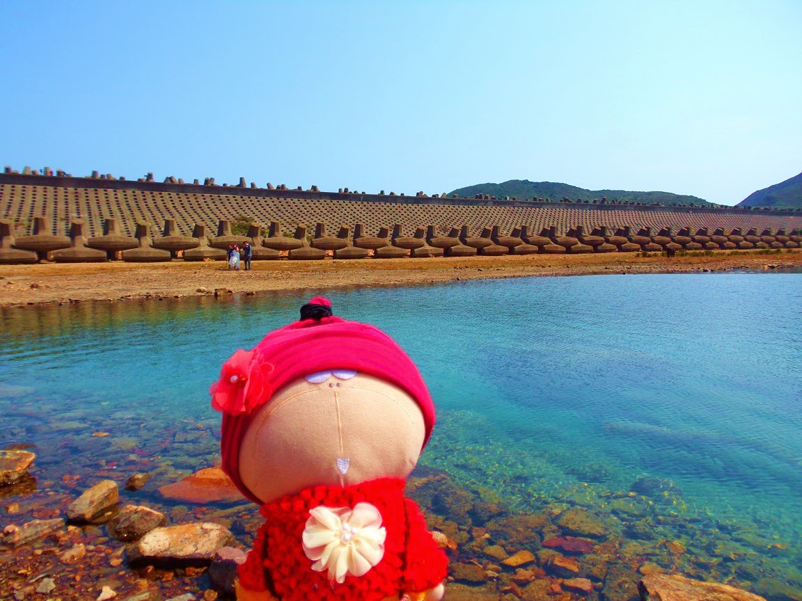
東壩景點 -- 錨型石, 用作防浪及防蝕.
East dam Specials --- Dolosse (Dolos in singular) along East Dam, which are used to protect harbour walls from the erosive force of ocean waves.


走近水邊 --- 有海洞及水牛!!!!!
We were near the water --- with a sea cave and a buffalo!!!


更多錨型石..... 巨人的鎚子?!?!?!?
More dolosse here.... hammers for giants?!?!?!?


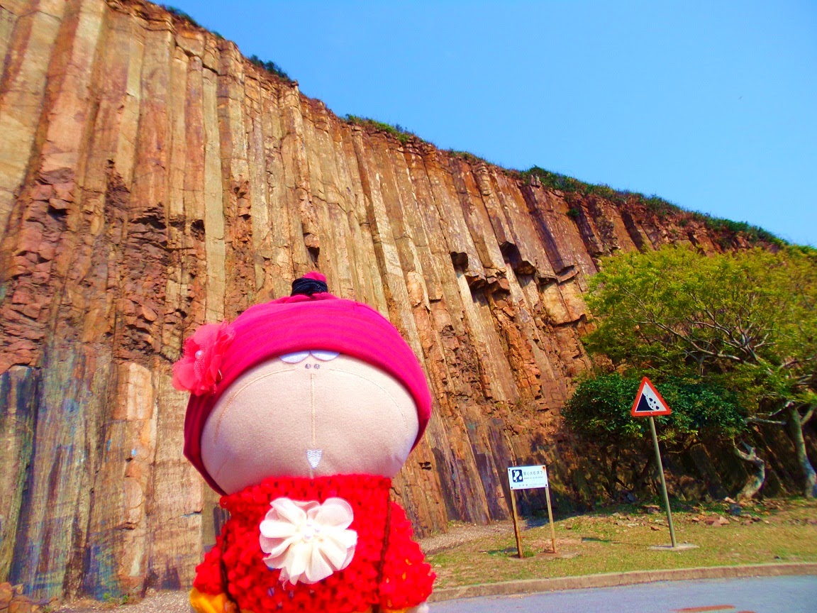
東壩著名的六角柱石.
Hexagonal stone columns @ the East Dam.


摺疊的石柱群, 由火山活動形成.
Strange landform from magmatic activities.

沿東壩前走, 向西壩進發.
We were walking on East Dam, now going to West Dam.


錨型紀念碑, 紀念昔日為興建水庫而亡的工作人員.
A dolos-shaped monument -- in memory of the staff who died in accidents during the construction of High Island Reservoir.

當花老 B 遇上花山......
Fa Shan peak (Flower Peak) @ the back of Tachibana san.....


白腊營地 --- 下面是白腊仔海灘.
Pak Lap Campsite --- you can go down to Pak Lap Tsai beach from here.


白腊村的入口 --- 下山可到達白腊灣.
The entrance for Pak Lap Village -- you can reach Pak Lap Wan (beach) from here.


想不到這裡有不少村落!!!!!! 可惜仍有一大段路要走, 我們很想到山下的沙橋看看漁村, 但真的沒有足夠時間!!!!
Oh, there are still a number of villages @ the seaside!!!! A pity we still had a long way to go, really did not have enough time to visit all these villages, especially the one called "Sha Kiu Tau", an old fishermen village with lots of boats on the water......

@ 糧船灣觀景台.
Now @ High Island (Leung Shuen Wan) View Compass.

到了西壩, 下面是創興水上活動中心, 還有天文公園在附近, 可惜實在太遠, 再無力下山了.....
We arrived West Dam and nearly exhausted.... Chong Hing Water Sports Centre is at the seaside, with an astro-park for star-watching!!!
We really did not have enough energy to go down, and it was getting darker and darker...... 17:00 now....


西壩大碗
Big bowl of West Dam.

天色已暗, 最後一個景點 --- 元五墳觀景台.
Already dark.... and our last scenic spot -- Yuen Ng Fan View Compass.


終於到了萬宜路的出口, 再接上大網仔路. 現在是17:30, 由於附近沒有巴士站, 我們仍有一段路要走.....
Now already 17:30, we were @ Sai Kung Man Yee Road exit. As there is NO bus-stop along this road, we turned to Tai Mong Tsai Road and continued our walk for the nearest bus-stop.

努力地向西貢方向走.....
Squeezed the last bit of our energy for the way to Sai Kung.

17:50, 終於到了上窰村外的巴士站....... 今天17 公里大長征, 到了尾聲, 大家都餓得雙腳發軟.
Finally we reached the bus-stop outside Sheung Yiu Village @ 17:50, ended our 17-km super long walk for today!!!
Time for dinner!!!!!!!!!!!


