Long Walk @ Yung Shue O and Sham Chung
(沙田火車站→沙田新城市廣場巴士總站→九巴 299號→水浪窩下車→企嶺下海→榕樹澳→深涌→深涌碼頭→渡輪往馬料水碼頭→大學站)
(Shatin Railway Station→New Town Plaza Bus Terminus→KMB bus no. 299→Get off @ Shui Long Wo→Three Fathoms Cove [Kei Ling Ha Hoi]→Yung Shue O→Sham Chung→Sham Chung Ferry Pier→Ferry to Ma Liu Shui public pier→University Railway Station)
古怪地名~~ 企嶺下海:
企嶺下海, 非常古怪的名字!!!
來源: "企嶺" 是馬鞍山的舊名, 所以企嶺下海, 即是馬鞍山下的海.
Kei Ling Ha Hoi (Three Fathoms Cove)
Kei Ling Ha Hoi, what a weird name...... you cannot guess the meaning of it....
It's "origin"~~ "Kei Ling" is the old name for Ma On Shan (mountain), "Ha" means below / under something, and "Hoi" means sea.
So, "Kei Ling Ha Hoi" means the sea under Ma On Shan mountain.
Although the official name should be "Three Fathoms Cove", people now tend to use "Kei Ling Ha Hoi", which is translated from the Cantonese pronounciation.
Album:
http://www.fotop.net/medalene/09mar13ShamChung?page=1
http://www.fotop.net/medalene/09mar13ShamChung?page=2
http://www.fotop.net/medalene/09mar13ShamChung?page=3
http://www.fotop.net/medalene/09mar13ShamChung?page=4
http://www.fotop.net/medalene/09mar13ShamChung?page=5
http://www.fotop.net/medalene/09mar13ShamChung?page=6
http://www.fotop.net/medalene/09mar13ShamChung?page=7
http://www.fotop.net/medalene/09mar13ShamChung?page=8
http://medalene.blogspot.com/2013/03/yung-shue-o-and-sham-chung.html


今天又是西貢行, 不過是經西沙公路那一方, 所以在沙田火車站起步!! 經新城市廣場第一期, 再到地下的巴士總站, 乘九巴 299號出動!!
A Sai-kung trip again!! But this time we started from Shatin Railway station (we were going to Sai Sha Road!!)~ we walked via Phase I of New Town Plaza, then we went downstairs to the bus terminus and then took a KMB bus no.299 which is for Sai Kung.


在西沙公路的水浪窩站下車, 附近便是榕樹澳的入口~ 今天我們會先經引水道步行45分鐘至榕樹澳村, 然後再經村內的小徑步行1小時至深涌. (全程大約90分鐘至2小時).
We got off @ Shui Long Wo bus-stop (@ Sai Sha Road) and then we were just near the entrance for Yung Shue O~~ first we have to walk along a long catchwater for 45-60 minutes for Yung Shue O village, and then another 1 hour for our destination~~ Sham Chung village! (This makes the whole walk for about 90 minutes to 2 hours)

對岸是企嶺下老圍.
The village at the opposite side is "Kei Ling Ha Lo Wai" village.

悶死人的45-60 分鐘引水道之旅由這裡開始!!
A boring 45-60 minutes' walk along the catchwater started from here!!


(上)榕樹澳的魚排 及 (下)企嶺下海
(Top)Fishing rafts of Yung Shue O and (Below)Kei Ling Ha Hoi / Three Fathoms Cove.


引水道之行完結後, 便進入榕樹澳的範圍. 榕樹澳村內的停車場旁, 有路牌指向深涌的方向, 主路只有一條, 不易迷路.
After the long walk along the catchwater, now we were @ Yung Shue O village. From the parking area of the village, there is a direction sign for Sham Chung (ONLY ONE footpath), you won't lose your way.

往深涌的路全程鋪上石屎, 平坦易走, 綠色之旅開始!!! (後面的山好像是馬鞍山)
Very smooth and hiker-friendly road for Sham Chung, our GREEN trip is starting now! (The peak at the back is Ma On Shan, I think...)

假菠蘿好多個!!!! (露兜樹~ 海邊常有)
Pineapples!!!! See clearly, these are something else!! (Pandanus or screw pine, can be seen at beach-side)


榕樹澳的濕地及海邊.
Mangrove and the seaside of Yung Shue O.

遠處的萬宜水庫.
High Island Reservoir is very far away!


快到達深涌了~~ 這裡是深涌角.
We were near Sham Chung~ actually here is the sea cape of Sham Chung.

石橋的紀念碑~~ 立於1948年3月1日!!!! 是名副其實的古董!!!
A monument for Sham Chung Bridge~~ It is erected since 1 Mar 1948!!! Really an antique!!!!!!


深涌村口的河塘.
A pond just @ the entrance of Sham Chung Village.


令人尖叫的大片美麗草原~~ 深涌曾經被發展商建為高爾夫球場, 但後來因環保問題而擱置, 高球場發展不成, 但一大片草地及人工湖卻成了景點!!!
Oooooops!! See this large piece of grass ~~ a golf course was under construction in Sham Chung but finally is abandoned (due to environmental protection issues) , but artificial lakes and this large piece of grass are left behind~ now becoming the "scenic" spots of this place.


深涌村~~ 只剩下少量村民居住
Sham Chung Village~~ only a few people are still living in this place.


湖邊景色甚美
Beautiful ponds.


人工湖及棕櫚樹甚有東南亞渡假村風味~~ 椰林樹影....
Man-made lakes and palm trees making a perfect match~~ just like having fun in a resort village!!


深涌茶座其實也是村屋.
Sham Chung Cafe~~ just outside the village houses.


深涌的古老村屋, 已經荒廢了.
Old village houses being abandoned.
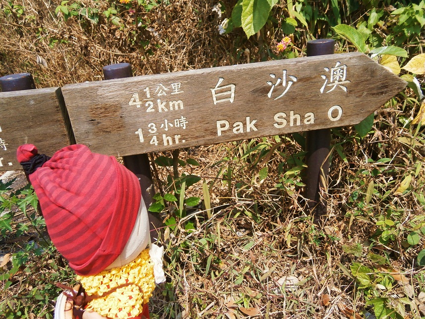

往白沙澳的方向, 內裡是一片荒蕪.
The way for Pak Sha O is really "Wild" look.....


叢林內有一所荒廢村校~~ 深涌學校, 只餘下牆壁, 校外已給野草吞噬, 野草至少高達 2米, 比我們還要高!!!
An old abandoned village school is here~! Sham Chung School, only 4 walls are left behind, the playground is being "swallowed" by the woods, with the grass over 2 metres (taller than us!!!).

往白沙澳的森林路就在村校旁邊, 有點陰森, 由這裡至荔枝莊的一段路全是林徑及山路, 非常荒蕪, 適合愛挑戰郊野的人. (荔枝莊至白沙澳才是平坦石屎路)
The forest track for Pak Sha O is just next to Sham Chung School, which is a bit dark and not so hiker-friendly.... The trail from here till Lai Chi Chong is a real "wild" track, with bumpy sandy road all along the way and may be a little bit of climbing is necessary. But sounds great for those who love wild-trekking!! (But concrete footpath is available from Lai Chi Chong to Pak Sha O)


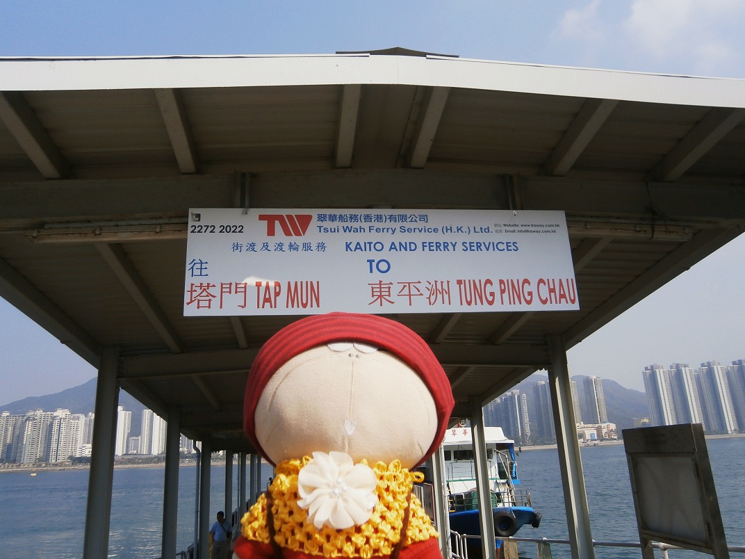
離開深涌村, 返回村口附近的深涌碼頭. 除了翠華船務的渡輪, 這裡亦有快艇可往附近的小島.
We left the village and back to Sham Chung Pier (near the entrance of the village). Besides the regular ferry services from Tsui Wah Ferry, there are speed boats available for islands nearby.


現在是14:15, 在碼頭等候14:30 回馬料水的假日特別渡輪.
Now 14:15. We were waiting @ the pier for the holiday special departure, which is for Ma Liu Shui public pier @ 14:30.


船來了..... 海上很涼快!!!!
The ferry is coming..... enjoying the sea-breeze!!!


30分鐘後, 終於到了馬料水碼頭!! 現在剛好3時!!! (假日特別班次14:30由深涌開出)
After a 30-minute's ferry ride, now we were @ Ma Liu Shui public pier!! Now 15:00!!! (The holiday special departure starts from Sham Chung @ 14:30)
沒有留言:
張貼留言